
Councillors call on state government to progress West Melbourne vision

The City of Melbourne used its first ever meeting in West Melbourne on March 15 to call on Minister for Planning Richard Wynne to sign off an amendment that would progress the West Melbourne Structure Plan ahead of the State Election.
The West Melbourne Structure Plan – known as Planning Scheme Amendment C309 – outlines the vision reimagining West Melbourne while respecting and leveraging its heritage and character as a distinct community separate from the central city.
That was the “overwhelming” sentiment shared following consultation with the West Melbourne community in 2019 when the City of Melbourne endorsed the vision, which sets out a number of exciting changes in postcode 3003.
Highlights include the creation of a new high street on Spencer St and 10,000 sqm of new public open space throughout the area, which the plan breaks up into five distinct precincts – Adderley, Flagstaff, Historic Hilltop, Spencer and Station Precinct.
Due to not enough councillors for a quorum at a meeting on May 7, 2019, the amendment was ultimately endorsed as Amendment C385 for referral to the Minister for Planning by a special committee of council in April 2020.
A report tabled by the council’s management and discussed by councillors at the Future Melbourne Committee (FMC) meeting held at the West Melbourne Baptist Community Centre on March 15 said officers had been working with the Department of Environment, Land, Water and Planning (DELWP) to “progress the amendment for ministerial consideration”.
"The determination of the amendment prior to the Victorian Government caretaker period commencing would be welcomed," the report stated.
Deputy chair of the council’s planning portfolio Cr Rohan Leppert described the government’s delay in signing off on the plans to North West City News in February 2021 as “unnecessary” and “very frustrating”.
He said the plans were “basically just sitting on the Minister’s desk.”
“We worked hard to design a strong planning framework that the West Melbourne community and the property industry alike supported. It was endorsed by the Minister for Planning’s own planning panel of experts, and the final version was approved by the council’s delegated committee back in May 2020,” Cr Leppert said.
Lord Mayor Sally Capp will now write to Minister for Planning Richard Wynne to “invite a determination on Amendment C385 as a priority” after councillors voted unanimously in favour of the move at the FMC meeting.
The council’s planning chair Deputy Lord Mayor Nicholas Reece told the meeting he had spoken to Minister Wynne “today” and that he expected a decision to be made immenently.
“I have been in contact with Richard Wynne today and I do believe a decision is imminent by the Minister. That is great news for the people of West Melbourne,” Cr Reece said.
Lord Mayor Sally Capp said, “This plan is well developed and has been with the minister for some time and we need to have that approval so we can work on the detailed plans that sit within the vision.”
The new West Melbourne Structure Plan replaces the previous version, which was completed back in 2005.
Key priorities to emerge from community consultation in 2019 included “a sense of community”, appropriate redevelopment and building heights, certainty from the planning process, more public and active transport and more parks, open spaces and greening.
Adderley, which is bound by Railway Place, Spencer St, Abbotsford and Rosslyn St, is characterised by height controls of two to four storeys in order to respect the area’s heritage buildings. Retail, commercial and artistic activities are also flagged.
Flagstaff is enclosed within King, Adderley, La Trobe and Dudley streets and located to the west of Flagstaff Gardens. This area will be developed as a central city fringe precinct with a mixture of building sizes and functions which include residential, education and commercial.
Historic Hilltop, located opposite the Queen Victoria Market (QVM), is bound by Peel, King, Roden, Dudley, Victoria, Lothian and Spencer streets. This area will retain its heritage character with evolving open spaces and wide green streets.
The Spencer precinct is the centre of West Melbourne and located between Roden, Dudley, Rosslyn, King and Spencer streets. The precinct will be mixed-use with mid-rise development under the plans.
A standout highlight of this precinct and the entire structure plan is the transformation of Spencer St into a central high street of West Melbourne. Tram and priority bus services will be extended to connect with Footscray and Arden, with the street to be rezoned as special use for the provision of more shops, cafes and restaurants.
Station Precinct will also offer a mixture of retail and hospitality surrounding the soon-to-be renamed West Melbourne train station (currently North Melbourne) with contemporary developments, terraces and warehouse conversions to complement the area’s heritage.
Update on transport and amenity program
The March 15 meeting also heard a number of updates on key projects being delivered by the City of Melbourne and the Department of Transport (DoT) as part of the North and West Melbourne and Docklands Transport and Amenity Program (TAP).
The program is a suite of streetscape improvement projects that will “help to alleviate and leverage some of the effects and benefits of the West Gate Tunnel Project” and is co-funded by the DoT and the council in a matched funding arrangement (up to a maximum of $100 million over the next four years).
The meeting heard updates on projects including the Spencer St North Masterplan (between Latrobe St and Dynon Rd), the new linear park at Hawke St and Franklin St improvements.
Of particular interest, however, were projects in which management said, “had already been delivered”, but not publicly disclosed, including the Connecting Docklands to North Melbourne Feasibility Study, Victoria St Opportunities Plan and Peel St Corridor Study.
The Docklands to North Melbourne project would see a pedestrian crossover constructed from Footscray Rd to North Melbourne Station over the railyards.
In relation to the finished projects, Cr Rohan Leppert asked the council’s TAP program director Rob Moore, “If they’re completed, can we see them?”
Mr Moore said all plans would soon “become public knowledge.”
While the West Melbourne Structure Plan proposed that the Docklands connection would come from Hawke St, Mr Moore said the feasibility study identified “real problems getting sufficient elevation.”
“We requested DoT to look at different alignments. By far and away the easiest is from Abbotsford St,” he said, adding that “the plus side of that is the two types of bridge links” that were possible, for both public and active forms of transport.
Other projects part of the program which are currently under construction include the Dynon Rd shared user path upgrades and Provost and Little Provost St upgrades, which are both due for completion this year.
Councillors also heard from a representative of local resident group the North and West Melbourne Association regarding the ongoing campaign from local residents for a sufficient sound barrier to be installed along Railway Place to mitigate noise pollution from the West Gate Tunnel Project.
In repsonse to a suggestion that the council fund the barrier through the TAP program, Mr Moore said while the council was supportive of the local community’s push, it wasn’t going to deal with issues created by the state government.
“It’s more important that we use our money to deal with projects that normally fall under council, rather than deal with a project that the state government have effectively created. We will continue to prosecute this matter vigorously,” he said •
Related Articles

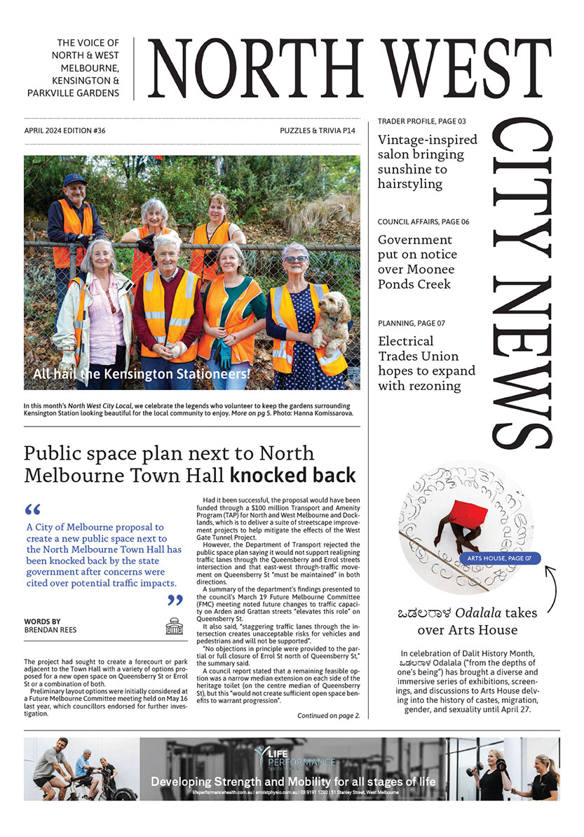
Public space plan next to North Melbourne Town Hall knocked back
A City of Melbourne proposal to create a new public space next to the North Melbourne Town Hall has been knocked back by the state government after concerns were cited over potential traffic impacts.
Read More
City of Melbourne puts state government on notice over Moonee Ponds Creek
City of Melbourne councillors have lashed the state government for its lack of progress in revitalising the city section of the Moonee Ponds Creek.
Read More
Council gets back control of laneways, leaving door open for community garden
The City of Melbourne has declared two laneways in North Melbourne as public highways, allowing it greater control to address concerns of traffic and safety issues and opening the opportunity of re-establishing a community garden.
Read More
Jo Ryan unveils Ordered Chaos at Blender Studios

Kensington Rec Centre construction progressing
 Download the Latest Edition