
Giant leap forward for Macaulay Precinct

The City of Melbourne has endorsed new planning controls to its ambitious Macaulay Structure Plan which addresses key issues of flooding, affordable housing, transport, and reflecting the “distinct character” of four new distinct precincts.
At their June 14 Future Melbourne Committee meeting, councillors considered Planning Scheme Amendment C417, which seeks to implement the planning controls of the structure plan – a vision that sets out a major urban renewal precinct in North Melbourne and Kensington spanning 90 hectares.
The new controls come after the council endorsed the structure plan with changes in November last year following community consultation. The planning scheme amendment represents the next important step in Macauley’s evolution by introducing the structure plan into the Melbourne Planning Scheme.
Among a number of amendments made since the council endorsed the original structure plan is rezoning the mixed-use zone to a “special use zone” to support a “genuine mix of uses in Macaulay”.
This includes managing land that is vulnerable to flooding as well as encouraging new developments to dedicate 20 per cent of their floor space to employment or other non-residential uses where permits are issued for accommodation to “support a greater mix of commercial/retail uses” in a bid to meet a projected 9500 jobs in Macaulay by 2050.
It also sets outs four new schedules to reflect the “distinct character” of Macaulay’s four sub-precincts – Boundary, Melrose, Chelmsford, and Stubbs.
These include floor area ratios, building heights, street wall heights, a “design excellence review process”, upper-level setbacks, active frontages, setbacks and new connections and laneways.
With the council hoping to achieve a diverse range of housing options, it has also proposed that new development include 3.8 per cent of the building’s floor area for affordable housing, equating to a projected 14 per cent across the entire Macauley precinct.
Changes to the precinct’s parking overlay will discourage on-site car parking on a site-by-site basis and “encourage consolidated, publicly available carparks and to encourage a travel mode shift toward sustainable transport options”.
In approving the new schedules, the council will now seek authorisation from Minister for Planning Richard Wynne to prepare and exhibit the planning scheme amendment.
According to a council report, the amendment is “generally in accordance with the structure plan although further modelling and analysis has resulted in the refinement of some built form requirements”.
Council officers have recommended the controls be implemented on an “interim basis,” rather than seeking a further extension to the existing interim built form controls which expire in June and September this year.
The council’s planning portfolio lead Deputy Lord Mayor Nicholas Reece said Macaulay “is a small but vitally important” part of the City of Melbourne.
While Cr Reece conceded it had “some wonderful pockets” there were “some parts” which were “not reaching anything like their proper potential,” in which he referenced the corridor between Boundary Rd and Moonee Ponds Creek.
“With this planning scheme amendment, we are looking to get right down into some fine grain planning detail that’s why we have divided the area up,” he said, adding the planning controls would allow Macaulay to develop and grow in a way which was “sensitive to the built form.”
Cr Reece also declared, “We want Macaulay to be our first EV [electric vehicle] ready suburb in Melbourne” with all new carparks in Macaulay to included charging infrastructure.
He added that the proposal to seek all developments to have at least 3.8 per cent affordable housing or developers to make an equivalent financial contribution to affordable housing would be a “game changer”.
He added that the plan included a new green space and pedestrian pathways.
North Melbourne resident Geoff Leach addressed the meeting saying while he gave “somewhat faint praise to the refresh”, he expressed concern that Arden Macaulay precincts were getting “massive amounts of dense high-rise development”, with the belief that buildings had gone from 20 metres high under original plans in 2012 to 36-metres plus under the current vision.
Cr Reece said while the council had “gone to great lengths to defend some of the controls” in the Moonee Ponds Creek-Boundary Rd corridor, he conceded “we have supported developments which are certainly higher than the 20 metres that were flagged back in 2012 but certainly a long way short of what some of the developers were shooting for”.
He added this corridor was “not everything that it could be” and believed the proposed controls “will get some really high-quality medium density living through there.”
However, he reiterated that there would be “plenty of scope for consultation” and encouraged all residents to make submissions.
Deputy planning portfolio lead Cr Rohan Leppert said the new set of controls were a “faithful representation of what that structure plan asks for.”
However, he did ask the question as to why the development contribution plan overlay, estimated by the council at more than $135 million, did not include five proposed Moonee Pond Creek bridges.
The council’s city strategy director Sophie Hanley said while it would be “desirable” to include the bridges, the “risk of committing council to such expensive items, particularly when we don’t control the land on either side of the creek, it was considered too higher risk.”
Related Articles

Kensington Rec Centre construction progressing
The Kensington Community Aquatic and Recreation Centre is moving closer to completion, with planned street closures in place this month to accommodate construction.
Read More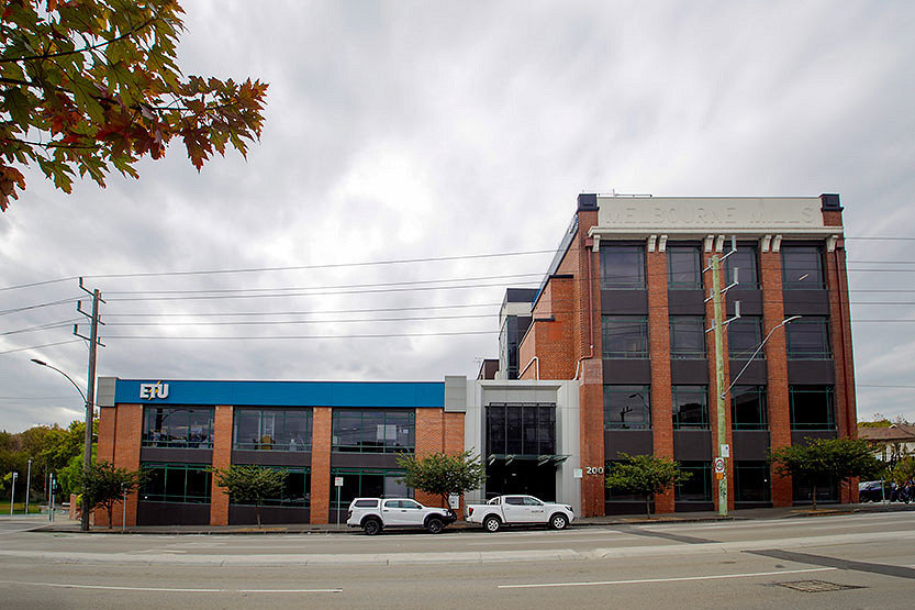
Electrical Trades Union hopes to expand with land rezoning
The Electrical Trades Union (ETU) has put forward a proposal to rezone its land to mixed-use so it can expand the offices of its North Melbourne headquarters.
Read More
Ozanam House supporting housing needs of LGBTIQA+ Victorians
North Melbourne's Ozanam House is at the heart of the Victorian Government initiative “Pride in Place”, which is supporting more than 570 LGBTIQA+ individuals across the state with access to safe and inclusive housing assistance.
Read More
Jo Ryan unveils Ordered Chaos at Blender Studios

Kensington Rec Centre construction progressing
 Download the Latest Edition