Council pushes to lock in land for parks and path in fast-growing Macaulay
The City of Melbourne is seeking stronger planning protection over a series of sites in Macaulay as it tries to secure land for future parks, drainage works and a key walking and cycling corridor in
the rapidly growing precinct.
A report to councillors for the March 17 Future Melbourne Committee meeting recommends the city advocate for a Public Acquisition Overlay across 17 sites in Kensington and North Melbourne identified in the Macaulay Structure Plan as needed for future public infrastructure.
In simple terms, a Public Acquisition Overlay, or PAO, is a planning tool that flags land the council may need to acquire in future for a public purpose, such as open space. It does not mean the council must buy the land immediately, but it puts landowners and developers on notice and helps prevent works that could undermine those long-term plans.
The issue has become increasingly urgent in Macaulay, where more than 1300 dwellings have been completed, are under construction or are planned, adding pressure on open space and supporting infrastructure.
The council says the precinct is growing quickly, but while funding mechanisms for new parks already exist, there is still no firm planning mechanism to actually secure the land. At present, that often relies on negotiations through individual planning applications, which can create delays and uncertainty.
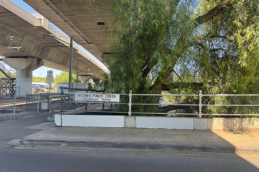
The report says the overlay should be pursued for land needed to expand Robertson Street Reserve, create the future Stubbs St open space, deliver the Macaulay Terraces drainage open space and establish an active transport corridor along the eastern side of CityLink between Racecourse Rd and Macaulay Rd. It also recommends applying the overlay to the full site at 296-304 Macaulay Rd, with officers arguing the property is already so constrained by the proposed corridor and setback requirements that broader public realm outcomes should be considered around Macaulay Station.
The recommended sites include private land, Crown land and land owned by VicTrack. That is where some of the main complications arise.
According to the report, some of the VicTrack land needed for open space is currently leased for commercial and rail-related uses, while one key site at 11-23 Stubbs St is also affected by a Registrar Caveat linked to its permanent reservation for railway purposes.
Officers say a PAO can still be applied to public land, but it would not by itself solve that transfer barrier. The council instead wants those issues elevated through an upcoming roundtable involving the Lord Mayor and state ministers.
The latest move comes only weeks after the state government sidelined the city’s long-running amendment process for Macaulay and replaced a planned independent panel with the new Macaulay Structure Plan Advisory Committee.
As reported by North West City News last month, that decision sparked frustration among residents worried about further delays and less certainty around the precinct’s future.
Now, council officers are recommending the PAO issue be folded into that same advisory committee process, with hearings due to begin on April 7. They say this offers the fastest pathway to resolving the matter.
The report notes that applying the overlays carries financial implications. The land under investigation is estimated to be worth about $42.8 million, mostly to be funded through development contributions and public open space levies, although some compensation costs may require separate future budget decisions.
For residents, the debate goes to the heart of a long-running Macaulay question: as thousands more homes are built, questions remain as to whether the public land needed to make the precinct liveable can actually be locked in before it is lost. •
Related Articles
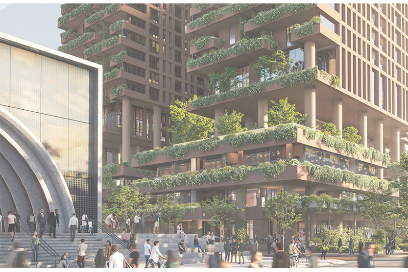
State fast-tracks Arden tower despite council warning
The Victorian Government has approved a controversial high-rise development next to the new Arden Station less than two weeks after City of Melbourne councillors warned the project risked undermining more than a decade of planning work for the precinct.
Read More
“An appalling process”: Council warns Macaulay vision is being pulled apart
The future of Macaulay now rests with Planning Minister Sonya Kilkenny after the City of Melbourne issued a damning response to a state-appointed advisory committee accused of unpicking more than a decade of planning work for Kensington and North Melbourne.
Read More
Arden tower backed, but only with major changes
One of the first major development proposals to emerge in Arden since the opening of the new Metro Tunnel station has received cautious backing from City of Melbourne councillors, but only if the Minister for Planning imposes significant changes.
Read More
One Star shines as a creative home

Arden tower backed, but only with major changes
 Download the Latest Edition